In this guide you will learn how pilots know the weather en-route and at destination.
You will learn all about aviation weather as part of the pilot's pre-flight preparation. After studying this guide, you will know how to use the significant weather charts and routine weather information such as the METAR, TAF and ATIS.
Knowing the weather in advance is very important to ensure a safe flight. When we expect bad weather at destination, we will take extra fuel so that we are prepared to hold and wait for the bad weather to pass. In all cases, also with good weather, we have a destination alternate if for any reason we can’t land at our destination airport.
For pilots, the most important weather details are:
WIND
VISIBILITY
PRECIPITATION
CLOUDS
TEMPERATURE
SIGNIFICANT WEATHER CHARTS
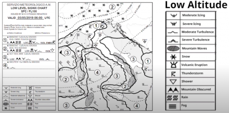
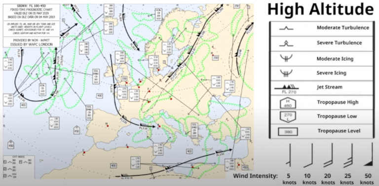
For the enroute phase of flight, we look at significant weather charts during our pre-flight preparation.
On the chart for low altitude, it shows the wind direction and intensity and the location of the clouds. You also find details about icing, turbulence, thunderstorms, mountain waves and different kinds of precipitation. When planning the flight, we avoid the areas of turbulence and big clouds.
On the high altitude chart, the one that is mostly used for commercial flights, you find similar details about turbulence and icing, but also about jet streams and the tropopause.
Jet streams are areas of very strong wind, usually at a very high altitude. Around the jet streams there is usually some turbulence, but it can also help us fly faster if it's pushing us in the right direction!
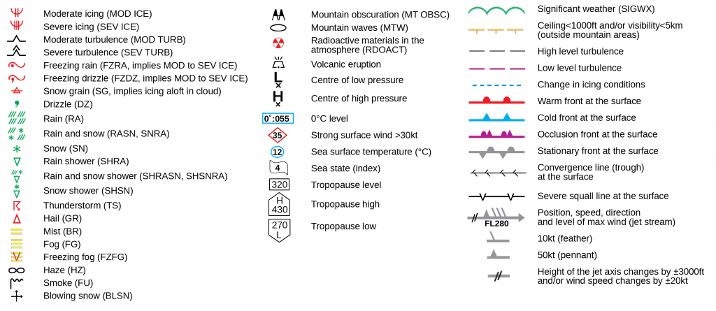
Here you find the meaning of the symbols used in the significant weather charts.
Besides the enroute weather data, it is very important to know the weather at our departure airport, destination airport and alternate airport. This is done by routine weather reports, such as the METAR, TAF and ATIS.
METAR
The currently observed weather is provided in half hourly bulletins called METAR: Meteorological Terminal Aviation Routine Weather Reports. Let’s have a look at this METAR from Verona! It may all seem a bit difficult, but you’ll see after explanation that it’s quite easy to understand!
Airport Identifier
Date and Time
Wind
Visibility
Precipitation
Clouds
Temperature
Dewpoint
QNH (Pressure)
LIPX
The first letters, Lima India Papa Xray is the airport identifier, the ICAO code for Verona Airport.
051220Z
Then it shows at what time the report was made. In this case it is made on the 5th of the month at 12:20 UTC.
34013KT
Next is the wind, coming from 340 degrees (North-North-Westerly wind) at 13 knots.
9000
Now we’re going to look at the visibility. This is given in meters, so right now at the field, we can watch as far as 9000 meters.
RA
The current precipitation. RA stands for Rain. It also indicates light or heavy precipitation, in that case it would be -RA for light rain and +RA for heavy rain. This is also the spot where they report thunderstorms, snow, hail and fog or mist. You can find some more abbreviations later on.
BKN040
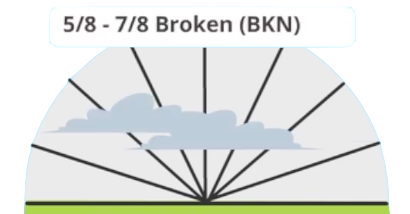
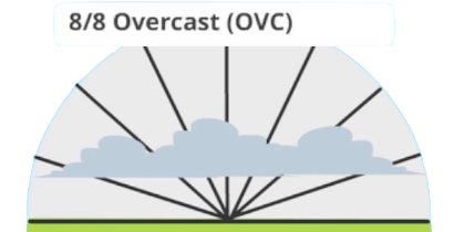
Now let’s have a look at the clouds. What we want to know is how much clouds are covering the sky and at what altitude. If we divide the sky above us in 8 parts, we can identify how much of the sky is covered. If the clouds are covering 1-2 parts, it’s FEW clouds. 3-4 parts is Scattered clouds. 5-7 parts is Broken clouds and 8 parts is overcast.
For the altitude, we should add two zeros to the number given. So in this case, we have 5-7 parts of clouds covering the sky at 4000 feet.
10/02
Next up is the temperature and the dewpoint. The temperature is 10 degrees and the dewpoint is 2 degrees celsius. The temperature is important to know as with low temperatures we may need to use our anti-icing methods for the engines, wings and tail. When the temperature is close to the dewpoint, we expect fog or mist.
Q1002
Finally, the QNH is reported at 1002 hectopascal. This value is needed for the altimeter of the airplane. If you’re curious to find out what is the QNH, have a look at my educational video about how pilots determine the airplane altitude.
For various weather there are many different abbreviations. Some abbreviations can be used together.
BR = MIST
DZ = DRIZZLE
FG = FOG
RA = RAIN
GR = HAIL
HZ = HAZE
SN = SNOW
TS = THUNDERSTORM
FZ = FREEZING
MI = SHALLOW
SH = SHOWERS
VC = IN THE VICINITY
Why don’t we try? Can you find out the meaning of the following abbreviations?
FZFG
FREEZING FOG
TSRA
THUNDERSTORM RAIN
VCTS
VICINITY THUNDERSTORM
SHRA
SHOWER RAIN
MIFG
SHALLOW FOG
FZDZ
FREEZING DRIZZLE
Now let’s have a look at the METAR of Palermo airport. Do you recognise something different?
Airport Identifier
Date and Time
Wind
Clouds and Visibility
Temperature
Dewpoint
QNH (Pressure)
Trend
CAVOK
Now, no visibility and clouds are reported! When the visibility is more than 10 kilometers and there are no clouds below 5000 feet (or minimum sector altitude, whichever is higher) and there is no current or forecasted significant weather such as precipitation, it will be reported as CAVOK: Ceiling (or Clouds) and Visibility OK!
NOSIG
Sometimes, in the METAR, you find a trend: A little prediction for the coming 2 hours. This can be indicated by the word TEMPO followed by the forecasted weather. In this case, NOSIG is a trend message informing the pilots that no significant change is expected to the reported conditions within the next 2 hours.
TAF
Whilst the METAR gives information about the current weather, the TAF (Terminal Aerodrome Forecast) gives a weather forecast. The data is quite similar, but let’s have a look at this TAF from Venice Airport!
Airport Identifier
Date and Time
Wind
Wind
Visibility
Clouds
Temporary Change
TEMPO Validity
Thunderstorm Rain
Gradual Change
Gradual Change Starting
Wind Change
LIPZ
First, the identifier, Lima India Papa Zulu: Venice airport.
050500Z
Time of publishing is the 5th of the month at 05:00 UTC.
0506/0612
As this is a weather forecast, we are interested in the validity of this report. It shows that it is valid from the 5th of the month at 0600 UTC until the 6th of the month at 1200 UTC.
04020G30KT
Next is the wind. It shows a wind from 040 degrees (North-North-Easterly) wind at 20 knots, but with gusts, sudden moments of stronger winds, of 30 knots.
9999
The visibility is 10 kilometers or more, this is indicated by 9999.
FEW030
We expect FEW clouds at 3000 feet.
TEMPO
Next up is a temporary change, lasting for periods of 30 minutes or more, but not longer than one hour and does not cover more than half of the total indicated period.
0506/0509
In this case, the tempo is valid on the 5th of the month between 06:00 and 09:00 UTC.
TSRA
A thunderstorm will pass over the airfield between that timeframe.
BECMG
''Becoming'' indicates a gradual change of weather over a period and will remain that way for the rest of the TAF validity period.
0516/0518
In this example, the specific weather will arrive on the 5th of the month between 16:00 and 18:00 UTC.
04012KT
The wind will calm down to 12 knots, still from 040, north-north-easterly direction.
ATIS
When we are in the air and are approaching the destination, the weather may have changed since the last METAR that we received on the ground. Therefore when enroute, we can listen to a frequency where the ATIS can be heard. This is the Automatic Terminal Information Service. Let’s listen to the ATIS of Turin airport!
This is Turin ATIS Arrival and Departure information ALFA at 12:20. Type of Approach: ILS Y. Runway in Use: 36.
Transition Level: 75. Wind touchdown: 050 degrees, 3 knots. Direction Variable between 030 and 160 degrees. Stop-end: Variable 3 knots. Visibility: 10 kilometers or more. Clouds: Few 8000 feet. Temperature: 15 degrees. Dewpoint: -02 degrees. QNH 1003 hectopascal. You have received ATIS information ALFA.
Besides the weather, the ATIS may also give information about the airport. For example:
Wind Shear Runway 28.
Runway Condition: Damp.
Airport Information: Work in Progress.
Operational Information: Taxiway Yankee and Kilo Closed.
Wind Treshold 10 and Runway Visual Range Runway 10 Not Available.
In most weather situations, the airplanes can land. Airplanes aren’t made of sugar, so they won’t melt with some rain!
For pilots it’s most important to be proactive and to be aware of the weather to be expected!